Meelmane – Barry’s Cove – Butlerstown, Co. Cork
Well, last time I introduced you to the second part of the Seven Heads Walk. And because it was so relaxing and breathtaking, I thought we should do a few more sections, because the area is really something special. And it is summer time. Time to explore County Cork.
This time we start in Meelmane, not far from the place where we turned around last week. A good hint: It might be good to take your bathing clothes with you. And before I forget to mention, walking shoes are on this trail a huge advantage and highly recommended.
The total length of this walk is about 6 km one way and we had our second car parked in Butlerstown.
Lusitania Trail
We have parked one of our cars near the caravan park a bit outside of Meelmane. The old road passing by the caravan park is a dead end and short before the end, the ancient path starts behind the last house to the right. It leads through the fields down to Broadstrand.
Broadstrand
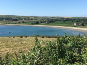
The strand is beautiful, safe and interestingly very clean. Now this would be the first possibility to use our swimsuit. We missed to take ours with us… what a pity.
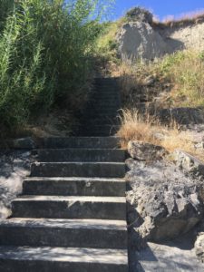
And so we walked on until the end of the strand.We had to cross a stream and the stoney end of the beach. At this end are steps that brings us up to an old road.
Blindstrand and Barry’s Point
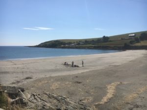
Keep left and walk downhill. The road turns left to the Blindstrand. It is smaller than the Broadstrand, but same safe and clean. Towards the end of this road are a few houses of the fisher hamlet called Coolbaun.
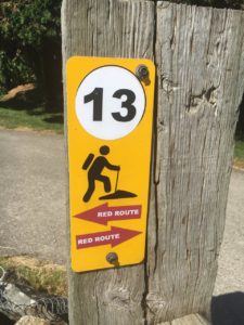
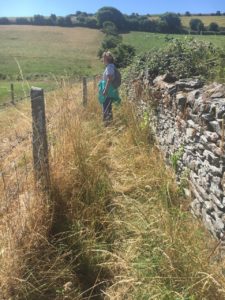
There is a house at the turn to Blindstrand. The house borders on a pasture and the path continues between house and pasture. There’s a path marking available, too. From now on it’s going uphill. After the first part you will reach an old road. Under the trees you can enjoy a rest from the climb.
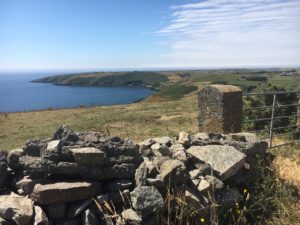
Turn now left and walk towards Barry’s Point. After about 150 m there’s another path marking to the right. This path leads to the highest point of the peninsula’s southern part. Of course, you can walk until the tip of this peninsula, but keep in mind you have to walk back.
Lackarour to Butlerstown
Once you have reached the summit the ocean comes into view again. And from now on it’s going downhill until you reach another old road. Step over the fence and enjoy the view.
The following few houses are part of Lackarour. Walk until the end of this road and you’ll reach Butlerstown. On your way to Butlerstown you will come to a small crossing. On the road left downhill, the trail continues towards Dunworley. But this will be our next walk. (And of course at this crossing is no path marking!)
Directions
From Dunkettle or Kinsale Rdabout take the N40 westward and use then the N71 which brings you directly to Bandon. Follow the N71 and just before leaving Bandon, turn left onto the R602 towards Timoleague. There’s a Roundhill gas station just before you have to turn left.
In Timoleague cross the bridge and turn the first left to the friary. You should now to pass the remains of the Franciscan Abbey. Take the next turn left into the R601 by crossing the next bridge and follow this road to Courtmacsherry. Almost at the end there is a Y-junktion. Straight ahead is the parking at the beach where we parked last time.
Today we turn right, going up the hill and then straight ahead. Follow the sign posts for the Co-op Supermarket. Before you reach the supermarket, turn left and follow this road to widely observable church. The road turns left at the church and straight ahead into Butlerstown. Once in Butlerstown go straight to the T-junction and turn left. Park one car at the left side on the street next to Butlerstown pub O’Neills.
With your 2nd car go to the caravan village, park there and start your walk.
I’ve been thinking a long time about which is the better way. I finally decided on the route via Courtmacsherry.
Meelmane (near the caravan village): 51°37′33″ N 8°42′4″ W
Butlerstown (next to the pub): 51°35′59″ N 8°43′35″ W
Broad Strand: 51°37′2″ N 8°42′6″ W
Blind Strand: 51°36′42″ N 8°41′35″ W
For all my readers who are dependent on public transport:
There is a bus to Timoleague, but the timetable is not really satisfying.
In this case, I highly recommend my People Walking Service.